- Suntory Global Innovation Center
- > Research & Technology
- > An introduction to water science
- > Our mission is to understand the Water Resource Cultivation area of the new Suntory Tennensui plant.
Research & Technology


The Chigawa River basin in the Matsumoto
Basin that was subject to study.
Until now, the three areas of the Minami Alps (Yamanashi Prefecture), Aso (Kumamoto Prefecture), and Okudaisen (Tottori Prefecture) were the water resources for (Mineral Water) Suntory Tennensui. However, a new fourth water resource will be created with the Suntory Kita-Alps Shinano-no-Mori Water Plant in the city of Omachi, Nagano Prefecture that is slated to start operations in 2021. This site was chosen from over 60 new potential water resources throughout Japan because the local people have lived closely with nature since long ago and continued to value and protect the safe, delicious water.
To realize even greater sustainable water utilization, we first engaged Prof. Nakaya from the Water Environment and Civil Engineering Division, Faculty of Engineering, Shinshu University as an advisor and began full-fledged hydrologic surveys in 2018 to understand the new plant’s Water Resource Cultivation area.
In order to continuously utilize groundwater into the future, it is important to obtain information on groundwater as well as surface water flowing above ground to increase understanding of the overall water cycle system. To that end, we aimed to visualize (quantify) the groundwater flow that is not visible to us judging by the flow of surface water that is visible to us.
The area of study was the Chigawa River basin in the city of Omachi, Nagano Prefecture. The geology of the 42 km2 mountainous area in the Matsumoto Basin surrounded by steep mountains is comprised of hard granite. At the foot of the mountains is an alluvial fan of sedimentary layers with good drainage. The new plant was to be built in a part of that area. Generally, in such conditions it is thought that much of the rainwater flows over the surface layer and seeps underground after reaching the sedimentary layers of the alluvial fan, since it is difficult for rainwater to seep underground in mountainous areas with hard bedrock. With this as our hypothesis we set out to verify whether the same could be said of this area.


We aimed to visualized groundwater flow judging by the flow rate of surface water, which is visible.
To carry out the verification, we used both physical and chemical methods to comprehensively evaluate groundwater flow.
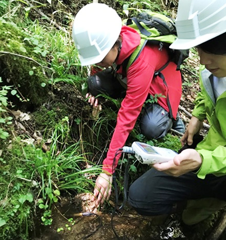
In the physical method, to understand the propensity of groundwater recharge we measured the flow rate of water flow on site. At places with abundant groundwater recharge, there is less water further downstream because rain seeps underground. Conversely, at places with low groundwater recharge, the further downstream the greater the flow rate. For this study, we chose places that seemed to display the characteristics of the water source where field surveys could be conducted. We began carrying out surveys on two occasions, during the dry season and the wet season, so that we could view seasonal changes.
Also, in the chemical method, to understand the propensity of places where the groundwater is recharged, we analyzed the stable isotopes* of hydrogen and oxygen in water collected during field surveys. We analyzed water collected from various spots to search for water that matches the stable isotopes of well water in the vicinity of the planned plant site.
As it was essential to make repeated visits for both methods, field surveys were conducted 8 times in 2019. In truth, conducting the surveys for this new plant was the first task I took charge of after joining the Institute for Water Science, and I remember how very difficult it was. We had to climb a 2,000 m high mountain with no hiking trails and travel upstream. Even so, as a member of Suntory, which operates plants, we have a responsibility to achieve highly sustainable water utilization, so no matter how difficult, I motivated myself by keeping in mind that the only way forward was to repeatedly conduct the surveys.
*Stable isotopes: Isotopes are atoms with identical properties, but of different weight (mass) depending on the number of neutrons. Among them, isotopes that are do not decay are called “stable isotopes.” These stable isotopes are considered natural tracking markers that exist in the natural world. Analyzing them can clarify the history of various material cycles.


Unlike the hypothesis, survey results showed rainwater penetrates underground in the northern basin of the mountainous area.
When we actually conducted the surveys, we found the river flow rate in the mountainous area increased downstream, but barely changed in the alluvial fan. Furthermore, when we looked closely at the mountainous area, we discovered a considerable amount of rainwater seeped underground in the northern part.
Also, a confirmation of the analysis results of the stable isotopes showed a difference in stable isotope comparison between the northern and southern parts of the mountainous area. A comparison of stable isotopes in water collected in the northern part and well water from the alluvial fan showed a match. Based on this, we concluded that the northern part of the mountainous area is an important recharge area for groundwater in the alluvial fan.
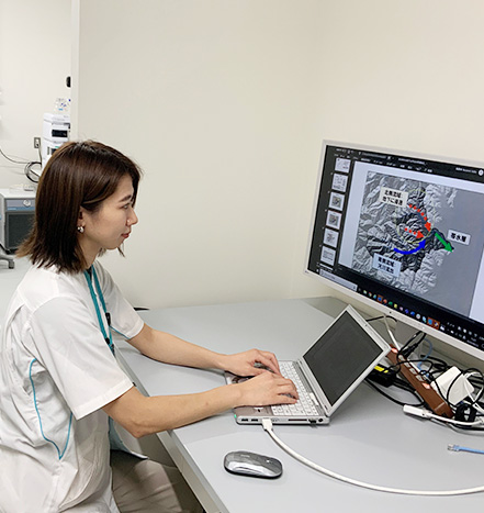
The surprising result completely differs from the prior hypothesis noted earlier. This would have never been known if we had not delved deep into the mountainous area and actually collected data. The results of these surveys were presented during the fall lecture series of the Japanese Association of Groundwater Hydrology held online in November 2020.
We also observed places in the site where spring water wells up, but since each one is a single point of information, we were not at all able to imagine at that time how they contributed to the overall water cycle.
However, I now realize that it is useful to consider not only the flow and water quality data, but also what I have seen in the field in order to properly understand the water cycle.

Why is it necessary to research matters such as the quantity and behavior of groundwater on site, such as in this study? It is because a company like Suntory that develops business using nature’s gift of groundwater as a resource has a responsibility to protect its sustainability. We must understand what happens and where, and how the groundwater is impacted to steadily continue using groundwater. Research aiming to understand the water cycle is crucial to achieving this.
In addition, unless we deepen understanding of water cycles in such sites, we will be unable to properly explain to local residents what areas of the river basin will or won’t be affected by the plant drawing up groundwater, and how much of that groundwater in the basin will be used at the plant.
Communicating this corporate approach has led to local residents welcome the Suntory Kita-Alps Shinano-no-Mori Water Plant. In 2019, staff from the Nagano Prefectural Government and Omachi City Hall happily participated in a mountain trekking event planned by a team from the new plant. Furthermore, based on this research, the approximately 1090 acre forest covering the northern basin of the Chigawa River has been established as the Suntory Tennensui no Mori Kita-Alps. To protect the sustainability of water in this region, we intend to communicate and work together with local residents to protect the Water Resource Cultivation area.
We went deep into the mountains where there were no trails, which led to a better understanding of the water cycle.

* The department name, title, and photo are as of the time of the production (interview).
- We gain the insights to protect our water resources to the future.
- Iyemon Tokucha. The story of how Suntory took up a new FOSHU challenge.
- Suntory shows its Yatte-Minahare - Go for it! spirit by developing blue roses
- "Follow Your Nature" with efforts to conserve precious water resources
and natural life forms. - List of research publications and presentations at academic conferences
- Understanding invisible groundwater flows
- First in the world to unravel the hop draft genome
- Uncovering carbonation’s powerful ability to cool and refresh
- Achieving better health with quercetin glucoside
- The science behind paring oolong tea with greasy food
- What are the compounds in green coffee beans that change depending on the maturity of the coffee cherries?
- World first! Suntory maps the genome of beer yeast
* The department name, title, and photo are as of the time of the production (interview).